Sherburn airfield is ideally located as a base to explore the fabulous scenery of the Yorkshire Dales, North York Moors, Yorkshire Coast, the Lake and Peak Districts. There are numerous castles, abbeys, and stately homes to see as well as the historic cities of York, Beverley and Ripon. There is also a dense network of airfields all within a short distance, including the Elvington and Breighton aircraft collections.
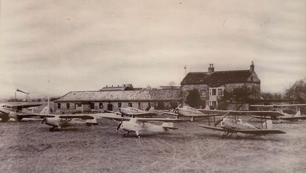
Sherburn in Elmet is a large village located in the Selby District of North Yorkshire between York and Leeds. The origins of the village go back to Roman times and the name reflects the fact that it was once within the Kingdom of Elmet. Today the village is known for its large industrial estate, located on part of a world war two airfield, the very same now operated by Sherburn Aero Club.
We are surrounded by some of the countries most beautiful countryside and yet are only a short distance from Leeds and York. Whether you are looking to go sightseeing and visit local attractions, take a walk in the Yorkshire countryside or you prefer retail therapy, you will not be disappointed.
Type | ICAO | Reg |
---|---|---|
Piper PA-28 Warrior | PA28 | G-BNDH |
Piper PA-28 Warrior | PA28 | G-BODE |
Piper PA-28 Warrior | PA28 | G-SACR |
Pilot | Flights | Club Hours |
---|---|---|
Paul A | 0 | 0h |
No club routes available for EGCJ yet.
EGNM 271850Z 29014KT 9999 FEW040 16/09 Q1017
Category: VFR
Wind: 290° at 14 kt
Recomended Runway 28 based on current wind conditions, with a headwind component of 13.8 kt and a crosswind component of 2.4 kt.
location_onLocation: 5.5 nm W of Selby, Yorks.
mapMap: Open in Maps
Runway: 10/28
Length: 829 m (2719.81636 ft) close_small 19 m (2719.81636 ft)
Surface: Asphalt
Headings: 103°,283°
Runway | Surface | Length | Width | Lighting | TORA / LDA |
---|---|---|---|---|---|
01 / 19 | Grass |
581 m 1906.16804 ft |
21 m 68.89764 ft |
Nil |
TORA: 553 m (1814ft) LDA: 553 m (1814ft) TORA: 553 m (1814ft) LDA: 525 m (1722ft) |
06 / 24 | Grass |
771 m 2529.52764 ft |
21 m 68.89764 ft |
Nil |
TORA: 723 m (2372ft) LDA: 676 m (2218ft) TORA: 696 m (2283ft) LDA: 703 m (2306ft) |
10 / 28 | Tarmac |
828 m 2716.53552 ft |
18 m 59.05512 ft |
Thr Rwy APAPI 3.5° |
TORA: 612 m (2008ft) LDA: 612 m (2008ft) TORA: 799 m (2621ft) LDA: 612 m (2008ft) |
10 / 28 | Grass |
622 m 2040.68248 ft |
21 m 68.89764 ft |
Nil |
TORA: 622 m (2041ft) LDA: 622 m (2041ft) TORA: 622 m (2041ft) LDA: 622 m (2041ft) |
Altitude: 24 ft AMSL
QFE Available: Yes -- Estimated QFE: 1017 hPa
Transition Altitude: 3000 ft
Name: SBL
Frequency: 323.0 kHz
Notes: —
Backtracking is not permitted on active runways.
Initial contact to be made with A/G not less than 5 DME via one of the VRP's (See bottom).
Limited space available, therefore all aircraft are normally required to park on Main Grass Parking. Surface markings; Yellow centre line, directional arrow guidance for refuelling. Yellow Hatched and Chevron markings for obstruction and hazard warnings surrounding the fuel points.
Runway marking aid(s):
10/28: Runway designation, runway centre-line, green reflectors for entry and run off. Runway 28: permanently displayed threshold.
Taxiway marking aid(s):
Alpha, Bravo and Charlie: Tarmac. Yellow centre-line with green
reflectors and blue edge reflectors. Holding positions.
Wind direction indicators: 1 south of midpoint of Runway 10/28, 1 south of Runway 24 threshold.
Fixed Wing 1000ft QFE.
Helicopters 700ft QFE.
Rwy 01 - RH Fixed Wing, helicopters LH.
Rwy 06 - RH Fixed Wing and Helicopters.
Rwy 10 - RH Fixed wing, helicopters LH.
Rwy 19 - LH Fixed wing, helicopters RH.
Rwy 24 - LH Fixed wing and helicopters.
Rwy 28 - LH Fixed wing, helicopters RH.
A/C Arriving. ALL FIXED WING A/C. MANDATORY STANDARD OVERHEAD JOIN at 2000ft QFE.
No departure info available.
No noise abatement information available.
Power cables 32ft aal cross final approach to runway 01, 258m from Thld.
Mast 134ft amsl (111ft agl) 830m to the east and south of runway 28 Thld and left of the extended runway approach centerline.
Ground Layout:
Circuit Diagram: