METAR Info
METAR EGXT 271020Z 26005KT CAVOK 19/06 Q1024 RMK BLU
Category: VFR
Wind: 260° at 5 kt
Recomended Runway 29 based on current wind conditions, with a headwind component of 4.3 kt and a crosswind component of 2.5 kt.
Ranksborough Farm - Ranksborough Farm
location_onLocation: 0.8 nm WWS of Langham.
mapMap: Open in Maps
settings_input_antenna Comms
Unicom U 122.800
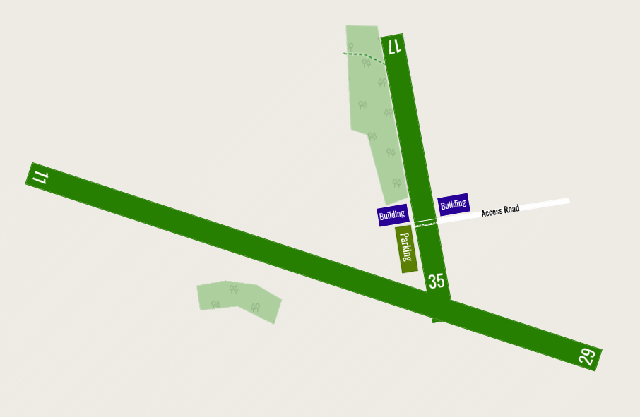
road Runways
Length: 1000 m (3280.84 ft) close_small 25 m (3280.84 ft)
Surface: Grass
Headings: 288,108
| Runway | Surface | Length | Width | Lighting | TORA / LDA |
|---|---|---|---|---|---|
| 17 / 35 | Grass |
480 m 1574.8032 ft |
20 m 65.6168 ft |
Nil |
TORA: m (0ft) LDA: m (0ft) TORA: m (0ft) LDA: m (0ft) |
| 11 / 29 | Grass |
1000 m 3280.84 ft |
25 m 82.021 ft |
Nil |
TORA: m (0ft) LDA: m (0ft) TORA: m (0ft) LDA: m (0ft) |
altitude Elevation & Pressure
Altitude: 463 ft AMSL
QFE Available: Yes -- Estimated QFE: 1024 hPa
Transition Altitude: 3000 ft
description Airfield Notes
This airstrip does not appear in little nav map you will have to use the coordinates here or other information to locate it.<br>A hill to the north can create rotor winds, and make it difficult to see the airfield.
loop Circuit & Procedures
Circuit Height 1000ft QFE.

Rwy 11/29 South of the field.

Rwy 17/35 West of the field.
volume_off Noise Abatement
Avoid overflying villages.
report_problem Warning
Power lines on approach to runway 29.
link External Resources
image Images
Ground Layout: