METAR Info
METAR EGTE 270950Z VRB02KT CAVOK 18/06 Q1024
Category: VFR
Wind: 0° at 2 kt
Recomended Runway 35 based on current wind conditions, with a headwind component of 2 kt and a crosswind component of 0.3 kt.
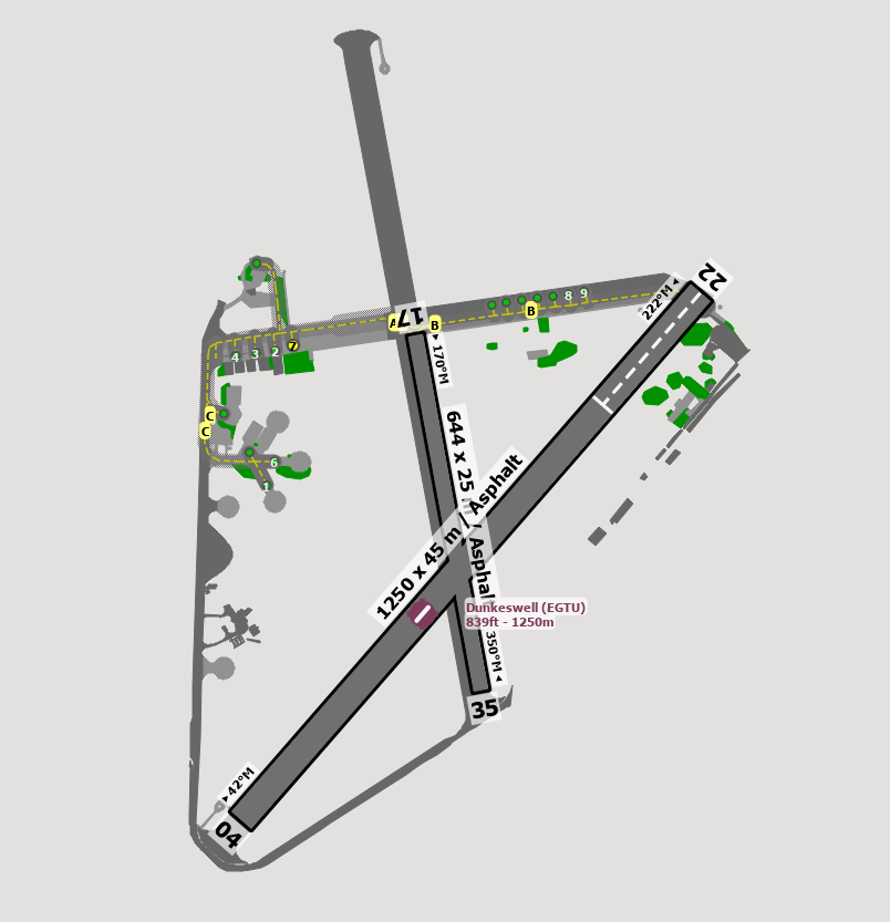
EGTU - Dunkeswell
location_onLocation: 14 nm NE of Exeter.
mapMap: Open in Maps
settings_input_antenna Comms
Dunkeswell Radio 123.480
road Runways
Length: 1250 m (4101.05 ft) close_small 45 m (4101.05 ft)
Surface: Asphalt
Headings: 222,42
| Runway | Surface | Length | Width | Lighting | TORA / LDA |
|---|---|---|---|---|---|
| 04 / 22 | Asphalt |
967 m 3172.57228 ft |
46 m 150.91864 ft |
On request / On Request |
TORA: 967 m (3173ft) LDA: 967 m (3173ft) TORA: 967 m (3173ft) LDA: 967 m (3173ft) |
| 17 / 35 | Asphalt |
963 m 3159.44892 ft |
46 m 150.91864 ft |
Nill |
TORA: 963 m (3159ft) LDA: 963 m (3159ft) TORA: 963 m (3159ft) LDA: 963 m (3159ft) |
altitude Elevation & Pressure
Altitude: 839 ft AMSL
QFE Available: Yes -- Estimated QFE: 1024 hPa
Transition Altitude: 3000 ft
radio Navaids
Name: BHD
Frequency: 112.1 kHz
Notes: R019 29.4DME
description Airfield Notes
Avoid the glider site at North Hill 1.5 nm WSW of the aerodrome.

Rwy 17/35 unlicensed.

Grass landing strip available on request.

Helicopters to call before starting rotors.

Use established taxiways/runways.
loop Circuit & Procedures
Circuits 800ft QFE aal.

Rwy 04 - RH.

Rwy 22 - LH.

Rwy 17 - LH.

Rwy 35 - RH.
flight_land Arrival
All arrivals from the south, to contact Exeter Radar.
flight_takeoff Departure
All departures to the south, to contact Exeter radar.
warning Caution
Free-fall parachuting from up to FL150, normally during day hours.

Pilots should positively identify the displaced landing threshold toRwy 22 before committing the acft to final.
link External Resources
image Images
Ground Layout: