METAR Info
METAR EGSH 271020Z COR VRB03KT CAVOK 17/05 Q1024 NOSIG
Category: VFR
Wind: 0° at 3 kt
Recomended Runway 02 based on current wind conditions, with a headwind component of 2.8 kt and a crosswind component of 1 kt.
EGSV - Old Buckenham
location_onLocation: 12 nm SW Norwich City.
mapMap: Open in Maps
settings_input_antenna Comms
Buckenham Radio 124.405
road Runways
Length: 850 m (2788.714 ft) close_small 17 m (2788.714 ft)
Surface: Asphalt
Headings: 244,64
| Runway | Surface | Length | Width | Lighting | TORA / LDA |
|---|---|---|---|---|---|
| 07 / 25 | Asphalt |
798 m 2618.11032 ft |
18 m 59.05512 ft |
Nil |
TORA: 798 m (2618ft) LDA: 798 m (2618ft) TORA: 798 m (2618ft) LDA: 798 m (2618ft) |
| 07 / 25 | Grass |
407 m 1335.30188 ft |
23 m 75.45932 ft |
Nil |
TORA: 407 m (1335ft) LDA: 407 m (1335ft) TORA: 496 m (1627ft) LDA: m (0ft) |
| 02 / 20 | Grass |
428 m 1404.19952 ft |
18 m 59.05512 ft |
Nil |
TORA: 370 m (1214ft) LDA: 428 m (1404ft) TORA: 428 m (1404ft) LDA: 370 m (1214ft) |
altitude Elevation & Pressure
Altitude: 194 ft AMSL
QFE Available: Yes -- Estimated QFE: 1024 hPa
Transition Altitude: 3000 ft
radio Navaids
Name: CLN
Frequency: 114.6 kHz
Notes: 357 39.1
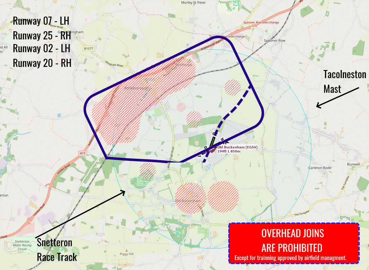
loop Circuit & Procedures
At 1000ft agl.

Rwy 07 - LH.

Rwy 25 - RH.


Runway 02/20 Procedures

Fly the main circuit, expect:

20 RH - Turn onto final when on the base leg for 25.

Departure:

Immediate right turn onto 270 before the priory in our SW corner.

02 - LH follow the approach for 07 then turn left over the file north of the priory on departure turn right to 040 until reaching the normal circuit.
flight_land Arrival
Rwy 07 joins from the west - report at Snetterton Heath; Rwy 25 joins from the east - report at Tacolnmeston Mast.
flight_takeoff Departure
Rwy 07 - Maintain runway heading until reaching 1500ft agl; Rwy 25 - Turn onto track 270 and maintain until reaching the railway line South of Attleborough.
volume_off Noise Abatement
Please avoid overflying the village of Old Buckenham (1 nm SSW of the airfield) and the town of Attleborough (2nm NW of the airfield)
report_problem Warning
Beware of the gliding site at Tibenham 5 nm to the SE.

Tacolneston Radio mast 888ft amsl, 3 nm NE of the airfield.

Norwich Class D airspace up to FL50 to the north.
link External Resources
image Images
Ground Layout:
Circuit Diagram: