METAR Info
METAR EGSH 271020Z COR VRB03KT CAVOK 17/05 Q1024 NOSIG
Category: VFR
Wind: 0° at 3 kt
Recomended Runway 06 based on current wind conditions, with a headwind component of 1.5 kt and a crosswind component of 2.6 kt.
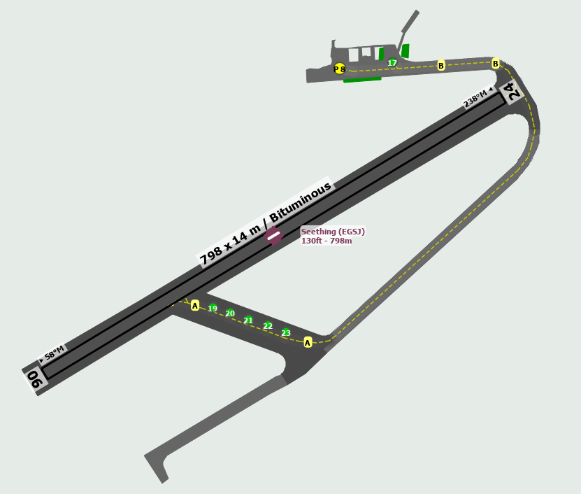
EGSJ - Seething
location_onLocation: 9nm SSE of Norwich
mapMap: Open in Maps
settings_input_antenna Comms
Seething Radio 118.435
road Runways
Length: 798 m (2618.11032 ft) close_small 14 m (2618.11032 ft)
Surface: Bituminous
Headings: 238,58
| Runway | Surface | Length | Width | Lighting | TORA / LDA |
|---|---|---|---|---|---|
| 06 / 24 | Asphalt |
799 m 2621.39116 ft |
18 m 59.05512 ft |
Nil |
TORA: 799 m (2621ft) LDA: 799 m (2621ft) TORA: 799 m (2621ft) LDA: 799 m (2621ft) |
altitude Elevation & Pressure
Altitude: 130 ft AMSL
QFE Available: Yes -- Estimated QFE: 1024 hPa
Transition Altitude: 3000 ft
radio Navaids
Name: CLN
Frequency: 114.6 kHz
Notes: R016 41DME
description Airfield Notes
Unlicenced Aerodrome.
loop Circuit & Procedures
Circuit Height 1000ft QFE.

Rwy - 06 RH.

Rwy - 24 LH.
flight_takeoff Departure
Rwy 06/24 climb straight ahead to 1000ft agl before turning on course.
volume_off Noise Abatement
Avoid overflying local villages.
warning Caution
Model Aircraft fly up to 300ft agl on the southern side of the southern perimeter track.

Motorcycle training may take place on the cross runways between the w/socks and disused taxiway to the N of the model flying area.
report_problem Warning
Distance between marked taxiway centre-line and parked aircraft can be as little as 8 metres, taxi with extreme caution.
link External Resources
image Images
Ground Layout: