METAR Info
METAR EGXC 270950Z 33006KT CAVOK 17/09 Q1024 NOSIG RMK BLU BLU
Category: VFR
Wind: 330° at 6 kt
Recomended Runway 29 based on current wind conditions, with a headwind component of 4.6 kt and a crosswind component of 3.9 kt.
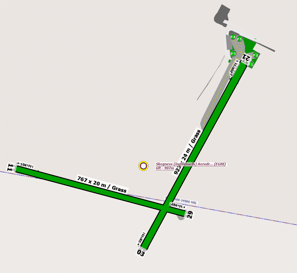
EGNI - Skegness
location_onLocation: 1.5nm N of Skegness.
mapMap: Open in Maps
settings_input_antenna Comms
Skegness Radio 132.430
road Runways
Length: 907 m (2975.72188 ft) close_small 22 m (2975.72188 ft)
Surface: Grass
Headings: 208,28
| Runway | Surface | Length | Width | Lighting | TORA / LDA |
|---|---|---|---|---|---|
| 03 / 21 | Asphalt |
799 m 2621.39116 ft |
23 m 75.45932 ft |
Nil |
TORA: m (0ft) LDA: m (0ft) TORA: m (0ft) LDA: m (0ft) |
| 11 / 29 | Grass |
650 m 2132.546 ft |
23 m 75.45932 ft |
Nil |
TORA: m (0ft) LDA: m (0ft) TORA: m (0ft) LDA: m (0ft) |
altitude Elevation & Pressure
Altitude: 10 ft AMSL
QFE Available: Yes -- Estimated QFE: 1024 hPa
Transition Altitude: 3000 ft
radio Navaids
Name: OTR
Frequency: 113.9 kHz
Notes: R156 35.2DME
loop Circuit & Procedures
Circuit Height 1000ft QFE.

Rwy 03/11 - LH.

Rwy 21/29 - RH.


Rwy 03 - ensure base turn is made before built-up area of Skegness.
warning Caution
Airfield dis subject to water logging in the winter months.


Wild life may be on rwys.


There is a tower/mast 1.4 nm North East of the airfield 70m agl.
link External Resources
image Images
Ground Layout: