METAR Info
METAR EGVO 270950Z 01005KT CAVOK 16/06 Q1024 NOSIG RMK BLU BLU
Category: VFR
Wind: 10° at 5 kt
Recomended Runway 03 based on current wind conditions, with a headwind component of 4.7 kt and a crosswind component of 1.7 kt.
EGHP - Popham
location_onLocation: 6 nm SW of Basingstoke.
mapMap: Open in Maps
settings_input_antenna Comms
Popham Radio 129.805
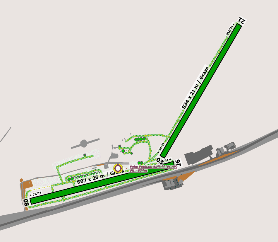
road Runways
Length: 824 m (2703.41216 ft) close_small 21 m (2703.41216 ft)
Surface: Grass
Headings: 210,30
| Runway | Surface | Length | Width | Lighting | TORA / LDA |
|---|---|---|---|---|---|
| 08 / 26 | Grass |
890 m 2919.9476 ft |
25 m 82.021 ft |
Nil |
TORA: m (0ft) LDA: m (0ft) TORA: m (0ft) LDA: m (0ft) |
| 03 / 21 | Grass |
900 m 2952.756 ft |
25 m 82.021 ft |
Nil |
TORA: m (0ft) LDA: m (0ft) TORA: m (0ft) LDA: m (0ft) |
altitude Elevation & Pressure
Altitude: 550 ft AMSL
QFE Available: Yes -- Estimated QFE: 1024 hPa
Transition Altitude: 3000 ft
radio Navaids
Name: CPT
Frequency: 114.4 kHz
Notes: R182 17.9DME
description Airfield Notes
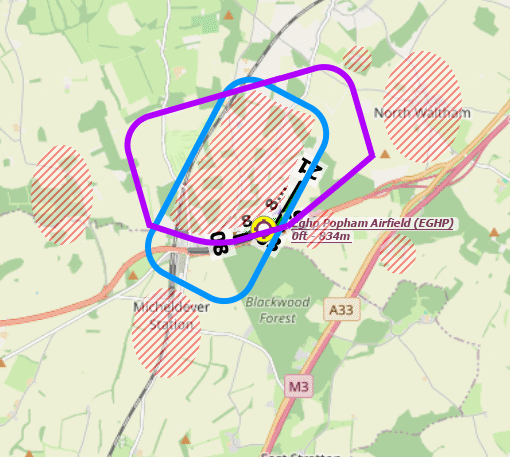
Please avoid overflying all housing in the area, all are noise-sensitive areas as the image below.


Aircraft are required to taxi as requested by AGCS and make contact as soon as

practicable to ensure two-way radio contact for the transmission of safety information.


Offset approaches to Rwys 08/26. Pilots MUST NOT approach over the filling station on short final to Rwy 26 or houses on approach to Rwy 08.


Run-ups should be done close to HOLDs, but not such that they block the expeditious use

of the runway by other aircraft
loop Circuit & Procedures
Circuit Height 800ft aal.

All circuits to the North.


Standard overhead joins are preferred at 2000ft aal if the cloud base allows.


Permanent dead side to the South.


Touch-and-goes on Runway 26 are prohibited except for based flying school instructors

and at pilot's discretion on Runway 08, 03, and 21.
report_problem Warning
Water Tower 60ft aal 610ft amsl in NW corner of aerodrome.
link External Resources
image Images
Ground Layout:
Circuit Diagram: