METAR Info
METAR EGHH 270950Z 06007KT CAVOK 19/02 Q1024
Category: VFR
Wind: 60° at 7 kt
Recomended Runway 08 based on current wind conditions, with a headwind component of 6.6 kt and a crosswind component of 2.4 kt.
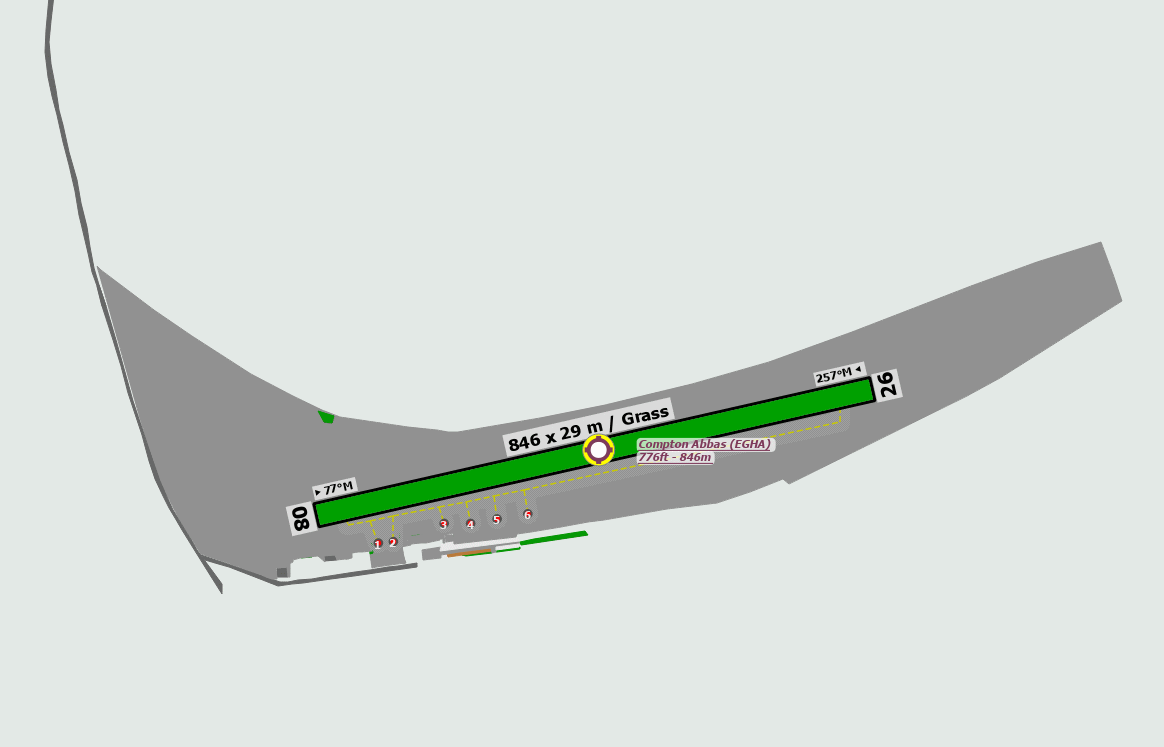
EGHA - Compton Abbas
location_onLocation: 2.8 nm SSW of Shaftesbury.
mapMap: Open in Maps
settings_input_antenna Comms
Compton Radio 122.710
road Runways
Length: 846 m (2775.59064 ft) close_small 29 m (2775.59064 ft)
Surface: Grass
Headings: 257,77
| Runway | Surface | Length | Width | Lighting | TORA / LDA |
|---|---|---|---|---|---|
| 08 / 26 | Grass |
799 m 2621.39116 ft |
30 m 98.4252 ft |
Nil |
TORA: 799 m (2621ft) LDA: 799 m (2621ft) TORA: 799 m (2621ft) LDA: 799 m (2621ft) |
altitude Elevation & Pressure
Altitude: 811 ft AMSL
QFE Available: Yes -- Estimated QFE: 1024 hPa
Transition Altitude: 3000 ft
description Airfield Notes
Do not confuse runway edge lines for runway centreline.


Due to prop-wash do not park aircraft facing north in front of the buildings.


Please respect grass surfaces, particularly in wet conditions. If landing long please consider another approach in order to avoid excessive braking which can cause the grass surface to be badly damaged.
loop Circuit & Procedures
Circuit Height 800ft QFE.

Rwy 08 - LH.

Rwy 26 - RH.

All traffic to join overhead or dead-side descending to 800 FT QFE to cross the upwind runway numbers.


Noise Abatement:

Departure.

Runway 08 - left turn as soon as practical in order to avoid Hatts Barn Farm.


Runway 26 - right turn as soon as practical after passing 200 FT AAL in order to avoid Compton Village, tracking over the crest of Melbury Hill.
report_problem Warning
The ground to the north of the runway has a steep slope gradient.


Trees along the southern aerodrome boundary will cause turbulence on the approach to Runway 08 and 26 when the wind has a southerly component.


Multiple trees penetrate the Approach and Take-Off Surfaces by as much as 23 ft. Multiple trees penetrate the Transitional Surface to south west of the runway by as much as 31 ft.


Beacon with strobe in Southern Transition Surface penetrates surface by 9 ft.


Check for any aerobatic or formation activity taking place within the ATZ.


Public footpath crosses runway at mid-point, aligned in a NW/SE direction.
link External Resources
image Images
Ground Layout: