METAR Info
METAR EGOS 270950Z 32008KT 9000 HZ FEW012 12/09 Q1026 NOSIG RMK BLU BLU
Category: VFR
Wind: 320° at 8 kt
Recomended Runway 32 based on current wind conditions, with a headwind component of 8 kt and a crosswind component of 0 kt.
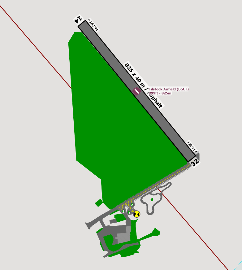
EGCT - Tilstock (Whitchurch)
location_onLocation: 2 nm S of Whitchurch (Shropshire)
mapMap: Open in Maps
settings_input_antenna Comms
Tilstock Radio 118.105
road Runways
Length: 825 m (2706.693 ft) close_small 40 m (2706.693 ft)
Surface: Asphalt
Headings: 322,142
| Runway | Surface | Length | Width | Lighting | TORA / LDA |
|---|---|---|---|---|---|
| 14 / 32 | Concrete |
600 m 1968.504 ft |
30 m 98.4252 ft |
Nil |
TORA: m (0ft) LDA: m (0ft) TORA: m (0ft) LDA: m (0ft) |
altitude Elevation & Pressure
Altitude: 90 ft AMSL
QFE Available: Yes -- Estimated QFE: 1026 hPa
Transition Altitude: 3000 ft
description Airfield Notes
Concrete Runway is east A41 and is in reasonable condition but often has a muck heap at one end.

The grass strip is adjacent to the concrete runway.


When airborne remain VMC and contact Shawbury Radar 133.150, climb not above 1000ft QFE until in contact with Shawbury.
loop Circuit & Procedures
No information is available, use your own discretion.
flight_land Arrival
Shawbury will provide LARS or FIS and radar vectoring if required.
flight_takeoff Departure
After the initial contact, or if no contact, turn either right from Rwy 32 or left from Rwy 14 onto heading 050°, remain VMC if possible, and continue to climb thereafter, turn onto the desired track as agreed with Shawbury Radar or abeam Audiem.
link External Resources
image Images
Ground Layout: