METAR Info
METAR EGXW 270950Z 32007KT CAVOK 16/07 Q1024 NOSIG RMK BLU BLU
Category: VFR
Wind: 320° at 7 kt
Recomended Runway 27 based on current wind conditions, with a headwind component of 4.5 kt and a crosswind component of 5.4 kt.
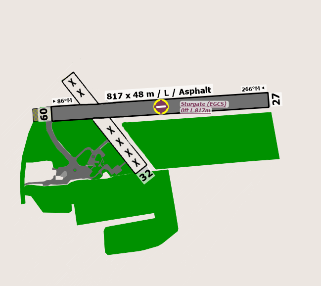
EGCS - Sturgate
location_onLocation: 4 nm SE og Gainsborough.
mapMap: Open in Maps
settings_input_antenna Comms
Sturgate Radio 130.305
road Runways
Length: 817 m (2680.44628 ft) close_small 48 m (2680.44628 ft)
Surface: Asphalt
Headings: 266,86
| Runway | Surface | Length | Width | Lighting | TORA / LDA |
|---|---|---|---|---|---|
| 09 / 27 | Asphalt |
820 m 2690.2888 ft |
46 m 150.91864 ft |
PAPI / AVASIS |
TORA: m (0ft) LDA: m (0ft) TORA: m (0ft) LDA: m (0ft) |
altitude Elevation & Pressure
Altitude: 58 ft AMSL
QFE Available: Yes -- Estimated QFE: 1024 hPa
Transition Altitude: 3000 ft
radio Navaids
Name: OTR
Frequency: 113.9 kHz
Notes: 231 28.2DME
description Airfield Notes
PPR Not required.
loop Circuit & Procedures
Circuit Height 1000 ft QFE.

Rwy 09 - LH.

Rwy 27 - RH.
report_problem Warning
EG-R313 Scampton should contact Waddington APP for restricted areas status. Check NOTAMS. Rwy 09 approaches. Use caution as the public road crosses the final approach. Rwy 09 departures: Aviod overflying the chicken farm (Green Shed) 1.5 nm on the departure heading and on the left side before the woodlands.
link External Resources
image Images
Ground Layout: