METAR Info
METAR EGXV 270950Z AUTO 34006KT 9999 NCD 16/08 Q1024
Category: VFR
Wind: 340° at 6 kt
Recomended Runway 26 based on current wind conditions, with a headwind component of 1 kt and a crosswind component of 5.9 kt.
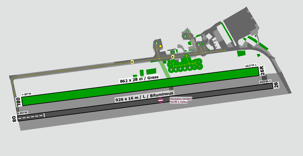
EGBS - Shobdon
location_onLocation: 5.4 nm W of Leominster
mapMap: Open in Maps
settings_input_antenna Comms
Shobdon Information 118.155
Shobdon Radio 118.155
road Runways
Length: 929 m (3047.90036 ft) close_small 16 m (3047.90036 ft)
Surface: Bituminous
Headings: 263,83
| Runway | Surface | Length | Width | Lighting | TORA / LDA |
|---|---|---|---|---|---|
| 08 / 26 | Asphalt |
839 m 2752.62476 ft |
18 m 59.05512 ft |
Thr Rwy / Thr Rwy APAPI 3.5° |
TORA: 799 m (2621ft) LDA: 836 m (2743ft) TORA: 799 m (2621ft) LDA: 836 m (2743ft) |
| 08 / 26 | Grass |
810 m 2657.4804 ft |
30 m 98.4252 ft |
Nil |
TORA: m (0ft) LDA: m (0ft) TORA: m (0ft) LDA: m (0ft) |
altitude Elevation & Pressure
Altitude: 317 ft AMSL
QFE Available: Yes -- Estimated QFE: 1024 hPa
Transition Altitude: 3000 ft
radio Navaids
Name: HON
Frequency: 113.7 kHz
Notes: R265 45.2DME
description Airfield Notes
Pilots should exercise caution taxiing to and from the Fuel Bay. Aircraft taxiing to the Fuel Bay cross a Bridleway which is used by vehicular traffic, not under the control of the aerodrome operator.


At all times, only one runway may be used for departing or arriving aircraft at any one time.


Overhead joins descend not below 1500ft aal on the dead side, further descent to circuit height when South of the runway.
loop Circuit & Procedures
Fixed wing circuit height 1000ft QFE, to the south of the villages of Pembridge and Eardisland (2 NM)

Helicopter circuit height 700ft QFE.

Microlight circuit height 500ft QFE.

Rwy 08 - RH.

Rwy 26 - LH.
report_problem Warning
Visiting pilots are warned of intensive gliding on the north side of the aerodrome. Aircraft joining overhead should not descend below 1500 FT QFE dead side due gliding. Descend to circuit height when south of runway centre-line.


Pilots should use the access taxiway to Runway 08 with caution. Distance between taxiway centre-line and fence is 10 M.


Departure from the marked movement area can be hazardous.


During periods of heavy rain runway is liable to have patches of standing water.


Pilots landing at night should land as near as possible to the centre of the runway as the surface on the two outer sections (width 36 M) is rough in places. Runway edge lights are not located along the declared width of the runway.


A boundary fence on the western edge of the paved taxiway leading to Taxi-Holding Point Bravo, infringes the taxiway strip by 5 M. The fence is marked with high-visibility/reflective markings


Windshear may occur when the following conditions apply: Mountain wave accompanied by wind with a northern component.
link External Resources
image Images
Ground Layout: