METAR Info
SPECI EGWC 271007Z 32007KT 3700 HZ SCT010 13/08 Q1026 RMK GRN
Category: IFR
Wind: 320° at 7 kt
Recomended Runway 34 based on current wind conditions, with a headwind component of 6.6 kt and a crosswind component of 2.4 kt.
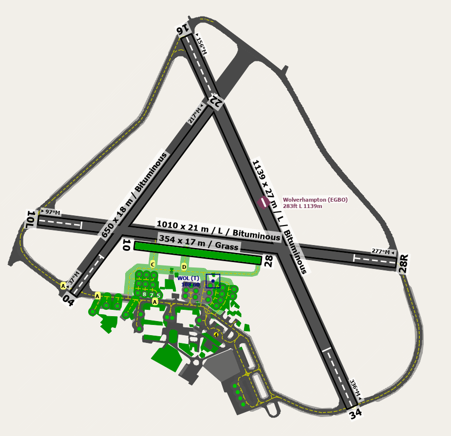
EGBO - Wolverhampton (Half Penny Green)
location_onLocation: 12 nm WWN of Birmingham.
mapMap: Open in Maps
settings_input_antenna Comms
Halfpenny Information 123.005
road Runways
Length: 1139 m (3736.87676 ft) close_small 27 m (3736.87676 ft)
Surface: Bituminous
Headings: 336,156
| Runway | Surface | Length | Width | Lighting | TORA / LDA |
|---|---|---|---|---|---|
| 04 / 22 | Asphalt |
646 m 2119.42264 ft |
18 m 59.05512 ft |
Nil |
TORA: 646 m (2119ft) LDA: 515 m (1690ft) TORA: 515 m (1690ft) LDA: 616 m (2021ft) |
| 10 / 28 | Grass |
350 m 1148.294 ft |
18 m 59.05512 ft |
Nil |
TORA: m (0ft) LDA: m (0ft) TORA: m (0ft) LDA: m (0ft) |
| 06 / 24 | Asphalt |
1055 m 3461.2862 ft |
18 m 59.05512 ft |
Nil |
TORA: 799 m (2621ft) LDA: 799 m (2621ft) TORA: 799 m (2621ft) LDA: 799 m (2621ft) |
| 16 / 34 | Asphalt |
1182 m 3877.95288 ft |
30 m 98.4252 ft |
Thr Rwy APAPI 3.5° |
TORA: 1025 m (3363ft) LDA: 858 m (2815ft) TORA: 1096 m (3596ft) LDA: 910 m (2986ft) |
altitude Elevation & Pressure
Altitude: 283 ft AMSL
QFE Available: Yes -- Estimated QFE: 1026 hPa
Transition Altitude: 6000 ft
radio Navaids
Name: HON
Frequency: 113.7 kHz
Notes: R294 24DME
description Airfield Notes
Pilots must moderate taxiing speeds on Taxiway A. This is due to undulating surfaces and between A4 and the Fuel Bay due to the possible presence of pedestrians in this area. Special caution must be exercised in the area adjacent to the tower where there is a marked crossing area.


Runway 04/22 use restricted to non-jet aircraft weighing not more than two tonnes.


Only Runway 16/34 is licensed for night use.
loop Circuit & Procedures
Fixed Wing Circuits 1000ft QFE and all LH.

Helicopters Circuits 800ft QFE and all RH.
flight_takeoff Departure
Rwy 10/28 Departures avoid Bobbington Village and school.
link External Resources
image Images
Ground Layout: