EGCB
|
53° 28′ 17.76″ N / 2° 23′ 23.09″ W
Manchester Barton
73 ft AMSL |
||||||||
|
cs Barton information Information: 0.120 AFIS |
||||||||
|
EGCC 290450Z AUTO 19008KT 150V220 7000 -RA BKN008/// OVC016/// //////TCU 12/11 Q1013 RERA REDZ | ||||||||
|
Wind Direction: 190° | Wind Speed: 8 kt
Best Runway: Rwy 20 – Headwind: 7.9 kt – Crosswind: from left 1.4 kt IFR Cloud Ceiling: 800 feet AMSL
QFE –1 / 1014 |
||||||||
|
Class D airspace, is Class D base 2000ft.. |
||||||||
 |
||||||||
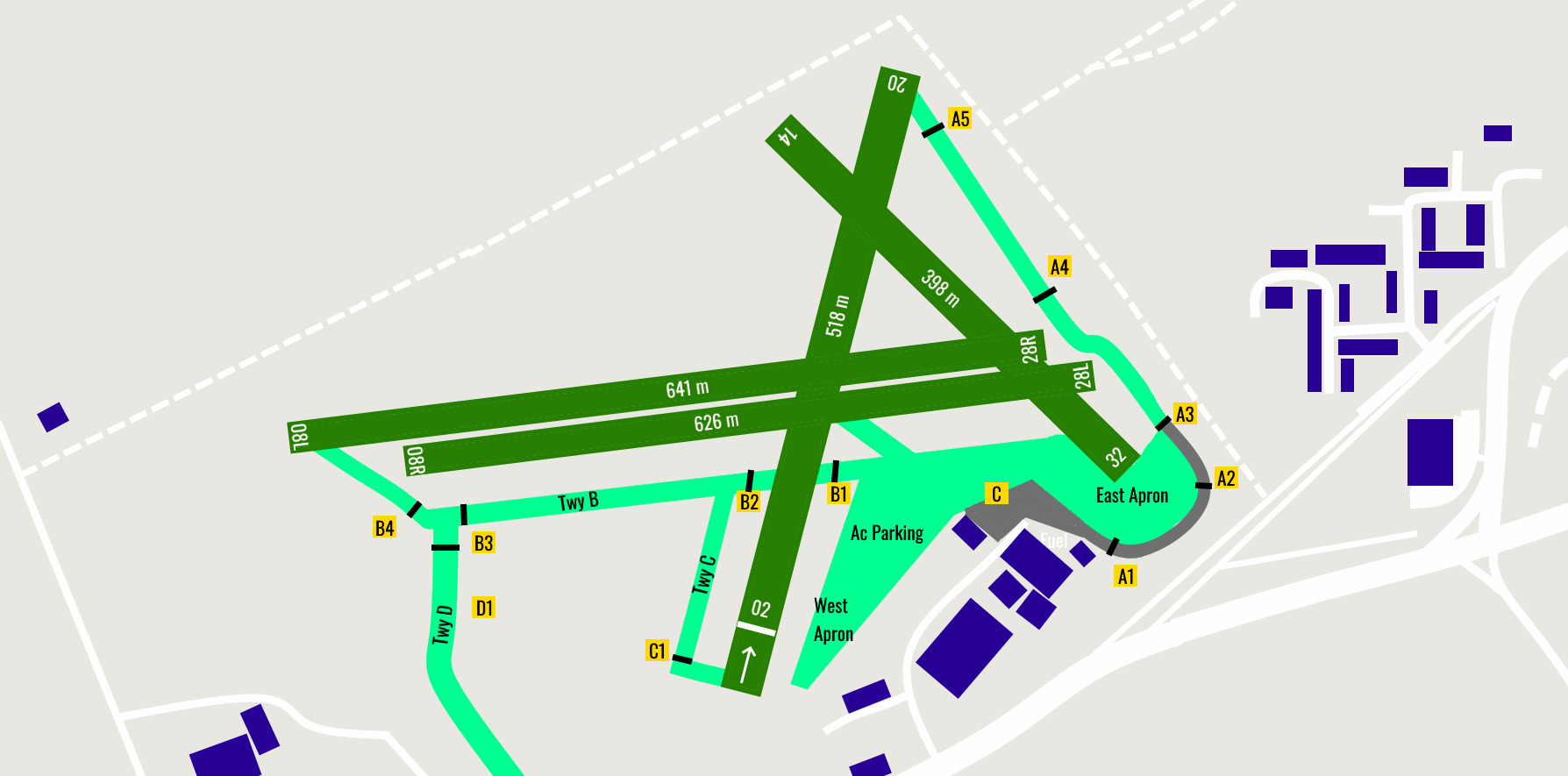
| Rwy | Dim(m) | Surface | TORA | LDA | Lighting | |||
|---|---|---|---|---|---|---|---|---|
| 02/20 | 518m x 32m 1,699ft x 105ft |
Grass | 02 – 518m 1699ft 20-518m 1699ft |
02 – 499m 1637ft 20-518m 1637ft |
Nil | |||
| 08L/26R | 641m x 30m 2,103ft x 98ft |
Grass | 08L – 641m 2103ft 26R-641m 2103ft |
08L – 641m 2103ft 26R-641m 2103ft |
Nil | |||
| 08R/26L | 626m x 32m 2,054ft x 105ft |
Grass | 08R – 626m 2054ft 26L-626m 2054ft |
08R – 626m 2054ft 26L-626m 2054ft |
Nil | |||
| 14/32 | 398m x 32m 1,306ft x 105ft |
Grass | 14 – 398m 1306ft 32-398m 1306ft |
14 – 398m 1306ft 32-398m 1306ft |
Nil | |||
| Landing Fees Single: 15.00 Points, Multi: 30.00 Points | ||||||||
|
Remarks Visitors can expect to be parked on the West Apron but only with ATS instruction. Aircraft in communication with Barton ATS may be allocated a conspicuity squawk of 7365. Aircraft must not select this squawk unless instructed to do so by ATS. Allocation of this conspicuity squawk does not constitute any radar service. Non radio aircraft not accepted. |
||||||||
|
Arrival Go-Arounds Approaches to runways must not be continued below 200 FT AAL if: The approach ahead or runway is occupied or obstructed by aircraft, vehicles or personnel. The PIC feels that the approach or landing is becoming unstable or unsafe. Go-Around Procedure To initiate the go-around, manoeuvre the aircraft to the deadside of the runway climbing parallel to the runway in use climbing to circuit height (1000 FT AAL) before turning crosswind. Exercise caution when low flying in the go-around over aircraft on the ground including helicopters air taxiing, personnel and vehicles. Ensure aircraft ahead are kept in sight. Do not manoeuvre onto the live side as this may conflict with helicopter operations. Do not climb initially above 500 FT AAL until you have passed the upwind end of the runway in use, which ensures maximum separation between you and aircraft joining overhead, flying crosswind at circuit height. |
||||||||
|
Joins Fixed winged standard join is overhead at 1700 FT Barton QFE. Pilots must inform ATS if performing a non-standard join prior to entering the ATZ. |
||||||||
|
Circuit Information Fixed winged circuit height is 1000 FT (Barton QFE). Circuit directions: Runways 14, 20, 26L, 26R – RH; Runways 02, 08L, 08R and 32 – LH. Orbits within the circuit are not permitted unless required for safety reasons. 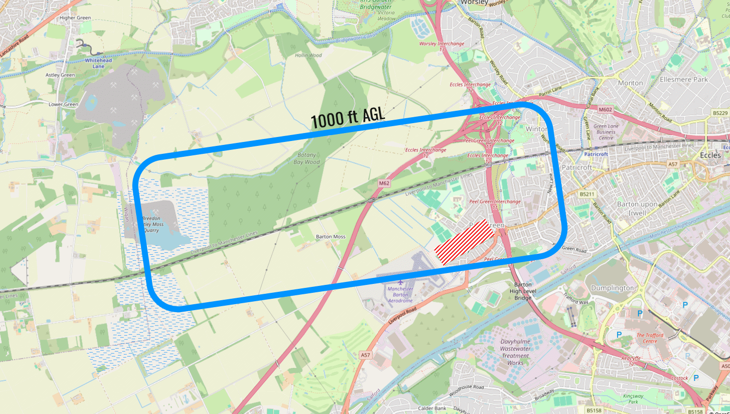
|
||||||||
|
Noise Abatement Pilots are to avoid overflying the cemetery to the Northeast of the aerodrome. Helicopters must avoid overflying the built up areas South and East of the airfield, indicated at AD 2.24. Climbing turns after take off should not normally be commenced below a height of 500 FT AGL except as indicated at c(i). Should pilots wish to make an early turn below 500 FT AGL on take-off, this may be permitted for safety reasons only. In this case, the ATS must be informed prior to commencement of the take-off roll. To minimise local noise disturbance when departing from Runway 20 and when safe to do so, upon reaching the Manchester Ship Canal aircraft should commence a right turn onto crosswind to avoid overflying the residential areas of Flixton and Irlam. |
||||||||
|
Warning Pilots should exercise caution as runway and taxiway surfaces undulate in places and may not be suitable for all aircraft types/weights. The surface may become soft during prolonged periods of wet weather. Further information may be sought by contacting the ATS. There are 35 FT high lamp standards on the A57 road to the Southeast and Southwest of the aerodrome. Red/White Marker boards or non-standard markings (cones) may be used to indicate areas of soft ground. Pilots must exercise extreme caution as not all soft areas may be indicated. Bird Hazard: Herons regularly flying across the aerodrome at heights between 100 and 500 feet. Additionally, Bird activity (Gulls and Pigeons) increases during periods of wet weather and grass seeding. All Bird Strikes must be reported. Windshear and Turbulence can be expected on approaches to all runways. In particular, conditions may be more prominent during the following conditions: Runway 26L/26R Approach and 08L/08R Climbout – Additional turbulence/windshear during strong winds (any direction) and/or high temperatures. Runway 20 Approach – Additional turbulence/windshear particularly during southeast to south winds. Runway 32 Approach – Additional turbulence /windshear during strong winds (any direction) and when crossing dual carriageway (A57) prior to the threshold. Runway 02 Approach – Additional turbulence/windshear, particularly when crossing dual carriageway (A57) prior to the threshold. Taxilane adjacent to AVGAS fuel installation has a reduced clearance of 10 M (from taxilane centre-line to fuel pumps). Parascending takes place on the aerodrome up to 1000 FT AAL during daylight, outside of published AD hours. Aerodrome is used unlicensed by helicopters H24. Category A Police and Air Ambulance helicopter flights take place H24 from the Aerodrome. Paramotors operate non-radio from a site approximately 2.5 NM West of the airfield during daylight hours. Runway 08R/26L transitional surface is impinged by the Control Tower building by 0.72 M. |
||||||||
| Visual Reference Points SWINTON INTERCHANGE – 53° 31' 23.99" N 2° 21' 36.00" W HULTON INDUSTRIAL ESTATE – 53° 32' 6.29" N 2° 27' 4.57" W WINTER HILL MAST – 53° 37' 32.02" N 2° 30' 53.75" W MIDDLEBROOK STADIUM – 53° 34' 49.98" N 2° 32' 8.02" W WIGAN LAKES – 53° 31' 16.82" N 2° 37' 40.26" W IRLAM BRIDGE – 53° 26' 20.00" N 2° 24' 47.02" W THELWALL VIADUCT – 53° 23' 26.02" N 2° 30' 20.99" W LEIGH FLASH – 53° 29' 22.99" N 2° 33' 34.99" W M60/M62/M66 Heaton Interchange – 53° 32' 59.16" N 2° 15' 39.04" W | No Scenery Available | Website Link | Video Link | |||||
| Sorted by Ident | Sorted by Name | ||||||||||||||||||||||||||||||||||||||||||||||||||||||||||||||||||||||||||||||||||||||||||||||||||||||||||||||||||||||||||||||||||||||||||||||||||||||||||||||||||||||||||||||||||||||||||||||||||||||||||||||||||||||||||||||||||||||||||||||||||||||||||||||||||||||||||||
|---|---|---|---|---|---|---|---|---|---|---|---|---|---|---|---|---|---|---|---|---|---|---|---|---|---|---|---|---|---|---|---|---|---|---|---|---|---|---|---|---|---|---|---|---|---|---|---|---|---|---|---|---|---|---|---|---|---|---|---|---|---|---|---|---|---|---|---|---|---|---|---|---|---|---|---|---|---|---|---|---|---|---|---|---|---|---|---|---|---|---|---|---|---|---|---|---|---|---|---|---|---|---|---|---|---|---|---|---|---|---|---|---|---|---|---|---|---|---|---|---|---|---|---|---|---|---|---|---|---|---|---|---|---|---|---|---|---|---|---|---|---|---|---|---|---|---|---|---|---|---|---|---|---|---|---|---|---|---|---|---|---|---|---|---|---|---|---|---|---|---|---|---|---|---|---|---|---|---|---|---|---|---|---|---|---|---|---|---|---|---|---|---|---|---|---|---|---|---|---|---|---|---|---|---|---|---|---|---|---|---|---|---|---|---|---|---|---|---|---|---|---|---|---|---|---|---|---|---|---|---|---|---|---|---|---|---|---|---|---|---|---|---|---|---|---|---|---|---|---|---|---|---|---|---|---|---|---|---|---|---|---|---|---|---|---|---|---|---|---|
|
|